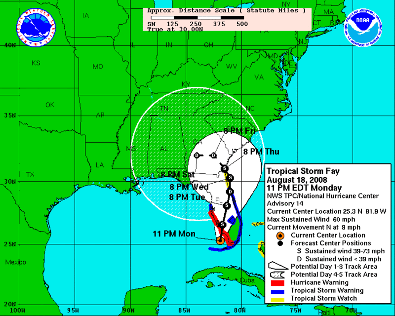
Issued at: 10:53 PM EDT 8/18/08 (gateway).
Fay continues heading for the southwest Florida coast,
A hurricane warning is in effect for the southwestern coast of florida from flamingo to anna maria island. A hurricane warning means that hurricane conditions are expected within the warning area within the next 24 hours. Preparations to protect life and property should have been completed.
At 11 pm edt, 0300 utc, the hurricane watch for the Florida west coast north of anna maria island to tarpon springs is discontinued. A tropical storm warning remains in effect for this area.
A tropical storm warning is in effect along the Florida east coast from flagler beach southward, including lake okeechobee.
A tropical storm warning remains in effect for the Florida keys from ocean reef to key west, including the dry tortugas, and for the florida mainland east of flamingo to card sound bridge.
A tropical storm watch remains in effect for the Florida east coast north of flagler beach to fernandina beach.
A tropical storm watch is in effect for the northwestern bahamas.
Interests elsewhere in Florida and the eastern gulf of mexico should monitor the progress of fay.
For storm information specific to your area, including possible inland watches and warnings, please monitor products issued by your local weather office.
At 1100 pm edt, 0300z, the center of tropical storm fay was located near latitude 25.3 north, longitude 81.9 west or about 60 miles, 95 km, south of naples Florida.
Fay is moving toward the north near 9 mph, 15 km/hr, and a slightly east of north motion is expected over the next day or two. On this track the center will cross the coast of southwest Florida tuesday morning and continue inland over central Florida later on tuesday and Tuesday night.
Maximum sustained winds are near 60 mph, 95 km/hr, with higher gusts. Fay could still approach hurricane strength prior to landfall. Weakening is likely while fay moves over the Florida peninsula.
Tropical storm force winds extend outward up to 125 miles, 205 km from the center. A wind gust of 59 mph, 94 km/hr, was recently reported at an elevated national weather service site at flamingo.
An air force hurricane hunter plane reported a minimum central pressure of 995 mb, 29.38 inches.
Storm tides of 3 to 5 feet above normal are possible along the southwestern coast of Florida near the center of fay. Tides of 2 to 4 ft above normal are possible in the Florida keys.
Fay is expected to produce additional rainfall accumulations of 1 to 3 inches over the central portion of cuba, with storm total amounts of 20 inches being possible. These rains could cause life threatening flash-floods and mud slides. Rainfall accumulations of 4 to 8 inches, with maximum storm total amounts of 10 inches, are possible for the Florida keys and the central and southern Florida peninsula. Rainfall accumulations of 3 to 5 inches are possible in the northwestern bahamas.
Isolated tornadoes are possible tonight and Tuesday over southern and central Florida.
Repeating the 1100 pm edt position, 25.3 n, 81.9 w. Movement toward, north near 9 mph. Maximum sustained winds, 60 mph. Minimum central pressure, 995 mb.
An intermediate advisory will be issued by the national hurricane center at 200 am edt followed by the next complete advisory at 500 am edt.
National Weather Service


No comments:
Post a Comment