Issued at: 10:40 PM EDT 8/17/08 (gateway).
Fay moving northwestward, soon to move over cuba,
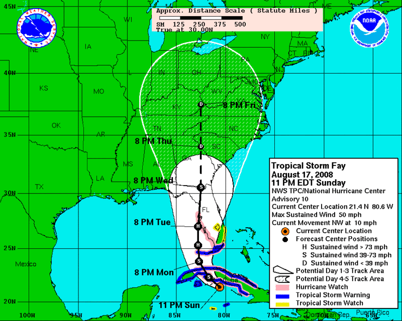
A hurricane watch is in effect for the Florida keys from ocean reef to key west, including the dry tortugas and Florida bay, and along the Florida mainland from card sound bridge westward to tarpon springs. A hurricane watch means that hurricane conditions are possible within the watch area, generally within 36 hours.
A hurricane watch remains in effect for cuba from the provinces of la habana and ciudad de la habana eastward to sancti spiritus.
A tropical storm warning is in effect for the provinces of cuba from camaguey westward.
A tropical storm warning remains in effect for cayman brac and little cayman.
At 11 pm edt, 0300 utc, the tropical storm warning is extended eastward along the Florida keys to ocean reef. A tropical storm warning is now in effect for the Florida keys from ocean reef to key west, including the dry tortugas and Florida bay. A tropical storm warning means that tropical storm conditions are expected within the warning area within the next 24 hours.
A tropical storm watch remains in effect for the southeast coast of florida from north of ocean reef northward to jupiter inlet, and for lake okeechobee. A tropical storm watch means that tropical storm conditions are possible within the watch area, generally within 36 hours.
A tropical storm watch remains in effect for grand cayman island.
Interests elsewhere in the Florida peninsula, the northwestern bahamas, and the eastern gulf of mexico should monitor the progress of fay.
For storm information specific to your area, including possible inland watches and warnings, please monitor products issued by your local weather office.
At 1100 pm edt, 0300 utc, the center of tropical storm fay was located near latitude 21.4 north, longitude 80.6 west or about 170 miles, 275 km, southeast of havana cuba and about 235 miles, 375 km, south-southeast of key west Florida.
Fay is moving toward the northwest near 10 mph, 17 km/hr, and a turn toward the north is expected during the next 1 to 2 days. On the forecast track, fay is expected to cross western cuba early on monday and move near the Florida keys Monday night.
Maximum sustained winds are near 50 mph, 85 km/hr, with higher gusts. Some strengthening is possible before the center crosses cuba, and fay could be approaching hurricane strength when it nears the Florida keys Monday night.
Tropical storm force winds extend outward up to 105 miles, 165 km from the center.
Estimated minimum central pressure is 1001 mb, 29.56 inches.
Storm tides of 2 to 4 feet above normal are possible along the south coast of cuba in the tropical storm warning area in areas of onshore winds. Tides of 2 to 4 ft above normal are possible in the florida keys in the warning area.
Isolated tornadoes are possible on Monday over the Florida keys and the southern Florida peninsula.
Fay is expected to produce total rainfall accumulations of 4 to 8 inches over much of cuba, with isolated maximum amounts of 12 inches. These rains could produce life-threatening flash floods and mud slides. Rainfall accumulations of 1 to 3 inches are possible over grand cayman and over the central bahamas. Heavy rain may begin to affect the Florida keys and south Florida tonight and into monday. Rainfall totals of 4 to 6 inches, with maximum amounts of 10 inches are possible for the Florida keys and south Florida.
Repeating the 1100 pm edt position, 21.4 n, 80.6 w. Movement toward, northwest near 10 mph. Maximum sustained winds, 50 mph. Minimum central pressure, 1001 mb.
An intermediate advisory will be issued by the national hurricane center at 200 am edt followed by the next complete advisory at 500 am edt.
National Weather Service


No comments:
Post a Comment