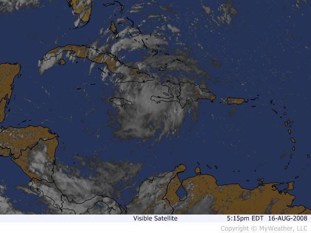
Issued at: 4:40 PM EDT 8/16/08 (gateway).
Fay weaker but re-organizing south of eastern cuba,
new warnings and watches for cuba, At 5 pm edt, 2100 utc, the government of cuba has issued a hurricane watch for the provinces of villa clara, cienfuegos, and matanzas. A hurricane watch remains in effect for the cuban provinces of camaguey, ciego de avila, and sancti spiritus. A hurricane watch means that hurricane conditions are possible within the watch area, generally within 36 hours.
At 5 pm edt, 2100 utc, the government of cuba has issued a tropical storm warning for the provinces of ciego de avila and sancti spiritus. A tropical storm warning also remains in effect for the cuban provinces of camaguey, las tunas, holguin, granma, santiago de cuba, and guantanamo. A tropical storm warning means that tropical storm conditions are expected within the warning area within the next 24 hours.
At 5 pm edt, 2100 utc, the government of the bahamas has canceled the tropical storm warning for the turks and caicos islands and the southeastern bahamas. Also at 5 pm edt, the tropical storm warning for haiti is canceled north of port-au-prince. A tropical storm warning remains in effect for the southwestern peninsula of haiti.
A tropical storm watch remains in effect for the central bahamas, jamaica, and the cayman islands.
Interests in western cuba, the Florida keys, and the Florida peninsula should monitor the progress of this system.
For storm information specific to your area, including possible inland watches and warnings, please monitor products issued by your local weather office.
At 500 pm edt, 2100 utc, the center of tropical storm fay was located near latitude 19.3 north, longitude 75.2 west or about 225 miles, 365 km, southeast of camaguey cuba and about 60 miles, 100 km, south of guantanamo cuba.
Fay is moving toward the west near 16 mph, 26 km/hr. A gradual turn toward the northwest with a decrease in forward speed is expected during the next couple of days. On this track, the center of fay will be near or over the southern coast of eastern and central cuba tonight and Sunday, and near or over western cuba sunday night or Monday.
Reports from an air force reserve hurricane hunter aircraft indicate that fay has weakened slightly. Maximum sustained winds are near 40 mph, 65 km/hr, with higher gusts. Strengthening is forecast during the next couple of days, and fay could be approaching hurricane strength as it nears western cuba.
Tropical storm force winds extend outward up to 105 miles, 165 km from the center.
The latest minimum central pressure reported by the hurricane hunter is 1006 mb, 29.71 inches.
Tides of 1 to 3 feet feet above normal can be expected in the warning area in areas of onshore flow.
Fay is expected to produce total rainfall accumulations of 4 to 8 inches over hispaniola, eastern and central cuba, jamaica, and the northern cayman islands, with isolated maximum amounts of 15 inches. These rains could produce life-threatening flash floods and mud slides. Rainfall accumulations of 2 to 4 inches are possible over jamaica and the northern cayman islands, while rainfall accumulations of 1 to 3 inches are possible over the southeastern bahamas.
Repeating the 500 pm edt position, 19.3 n, 75.2 w. Movement toward, west near 16 mph. Maximum sustained winds, 40 mph. Minimum central pressure, 1006 mb.
An intermediate advisory will be issued by the national hurricane center at 800 pm edt followed by the next complete advisory at 1100 pm edt.
National Weather Service

No comments:
Post a Comment